

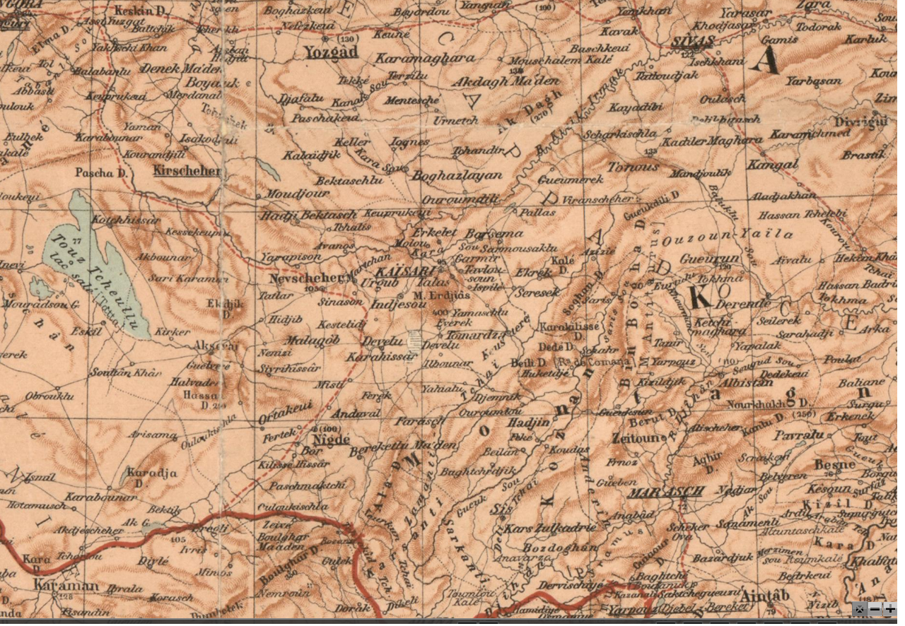
İncesulu tarihi haritalar veya tarihi haritalarda İncesu
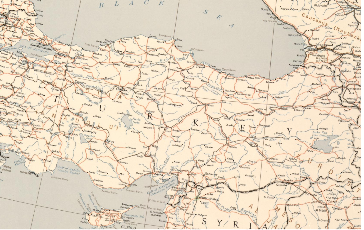
Kayseri, İncesu, Indjesu, Indjesou haritaları
 https://www.adscientificindex.com/add-profile-correction-form/?ref=banner
İncesulu tarihi haritalar veya tarihi haritalarda İncesu
kayseri, kaisari, incesu, indjesu, indjesou, map harita
Daha net görüntü için il
Not: Bazı dönem harita ve açıklamalarında katılmadığımız bazı siyasi unsurlar bulunmaktadır.
https://www.wdl.org/en/item/11737/view/1/1/ This map, published in Berlin in July 1916, shows the Turkish theater of World War I
https://www.wdl.org/en/item/11687/view/1/1/ This 1952 map by the Army Map Service of the U.S. Army Corps of Engineers provides a broad overview of the Near East, the geographic region traditionally thought of as encompassing the countries of southwest Asia, including Turkey, Lebanon, Syria, Iraq, Israel, and Jordan, and the countries of the Arabian Peninsula. In addition to political borders, the map shows lakes, rivers, and other bodies of water, marshlands, cities by population, pipelines, railroads, and pumping stations
https://www.wdl.org/en/item/11694/view/1/1/ This early 20th-century British map depicts the Euphrates Valley, a region that includes parts of present-day Iraq, Iran, Turkey, and Syria. Also shown is the northern part of the Arabian Peninsula. The map indicates railroads, both existing and projected, and the route of submarine telegraph cables. The vilayets(administrative provinces) of the Ottoman Empire in Syria, Mesopotamia, Palestine and southern Anatolia are marked by red lines.
https://www.wdl.org/en/item/11735/view/1/1/
This map of southeastern Europe and the eastern Mediterranean was made early in World War II by Fremde Heere Ost (Foreign Armies East), a unit of the German army general staff responsible for intelligence about the armies of the Soviet Union, Scandinavia, certain Balkan countries, Africa, and the Far East

https://www.wdl.org/en/item/11736/view/1/1/

https://www.wdl.org/en/item/11734/view/1/1/
New General Map of the Asian/Eastern Provinces of the Ottoman Empire: Without Arabia

https://www.wdl.org/en/item/13048/view/1/1/
Countries of the Ottoman Emperor in Asia, Persia, Uzbek Territory, Arabia, and Egypt
Description
This 1740s map shows the possessions of the Ottoman Empire in Asia (including present-day Turkey, Iraq, and the Levant), the Persian Empire (shown to include present-day Iran, Afghanistan, much of Pakistan, and the Caucasus), the country of the Uzbeks, Arabia, and Egypt. The boundaries of these territories are hand colored on this copy. The desert to the south and west of present-day Bahrain, Qatar, and the United Arab Emirates is described as “without water and without habitation.” The pearl-diving region of the southern Persian Gulf is indicated by shading and dots. In the southwestern part of the Arabian Peninsula are two noteworthy Biblical references: one to Moab, another to the Queen of Sheba. Also shown is the Red Sea town of Moka, a major exporter of coffee and the origin of the word “mocha.” The map is by Gilles Robert de Vaugondy (1688−1766), an important French cartographer who inherited the cartographic materials of the mapmaker Nicolas Sanson and his sons and who published atlases in 1748 and 1751

https://www.wdl.org/en/item/13044/view/1/1/
Map of the Near East
Description
German geographer and cartographer Heinrich Kiepert (1818–99) is generally regarded as one of the most important scholarly cartographers of the second half of the 19th century. He was head of the Geographical Institute in Weimar between 1845 and 1852 and professor at the University of Berlin from 1852 until his death. Shown here is Kiepert’s 1855 map of the Near East, which appeared in the Kiepert’s Neuer Hand-Atlas über alle Teile der Erde (Kiepert’s new portable atlas of all parts of the world), published by Dietrich Reimer, with whom Kiepert had a long association. The map covers the region between the eastern Mediterranean and the border of Afghanistan with British India. Different colors are used to mark the borders of the Ottoman and Russian empires, British possessions and protectorates in India, and the territory of the imam of Maskat (present-day Muscat). In the lower left-hand corner is a list of topographic terms in Turkish, Arabic, and Persian with their German equivalents.

https://www.wdl.org/en/item/11753/view/1/1/
Map of the Countries between Constantinople and Calcutta: Including Turkey in Asia, Persia, Afghanistan and Turkestan
Description
This 1885 map shows the region between Constantinople, capital of the Ottoman Empire, and British India, an area of intense imperial rivalry between the British and Russian Empires in the late-19th century. British possessions are colored in red and include British India, Cyprus, the Aden Protectorate (present-day Yemen), Socotra Island (Yemen), and the northern littoral of the Horn of Africa, which became the protectorate of British Somaliland (present-day Somalia) in 1888. The map shows railroad lines and submarine telegraph cables. The railroad network is at this time more developed in India and the Caucasus region of the Russian Empire than in the other areas shown on the map. Distances between major port cities are indicated in miles (one mile = 1.61 kilometers) on the telegraph lines and in the table showing distances between the Egyptian ports of Alexandria and Suez and the European ports of London, Marseilles, and Brindisi, Italy. The map is by Edward Stanford Ltd., a London map seller and publishing house established in 1853 by Edward Stanford (1827–1904), known for its London shop catering to famous explorers and political figures.
https://www.wdl.org/en/item/11734/view/1/1/
New General Map of the Asian/Eastern Provinces of the Ottoman Empire: Without Arabia
Description
This large map in French containing a wealth of detail about the Asian provinces of the Ottoman Empire is by the German geographer and cartographer Heinrich Kiepert. The map was created in 1884, but a note indicates that railroad routes have been updated to 1912. Important place-names are given in several languages. The Mediterranean Sea, for example, is listed in French, Greek, Turkish, and Arabic. A table at the bottom lists geographic terms in Greek, Turkish, Persian, and Arabic, with their French equivalents. The heights of mountains and bodies of water are given in meters above or below sea level. A note in the upper-right corner of the map lists the sources Kiepert used to compile the information on the map, including railroad and road-building surveys, records of archeological expeditions, accounts by such travelers as Hirschfeld, Ramsay, and Hartmann and Wünsch, and Kiepert’s own voyage to Palestine and Egypt in 1870. Kiepert was professor of geography at the University of Berlin for 45 years, from 1854 until his death in 1899. He worked in both modern and ancient historical cartography and had a particular interest in Asia Minor. His first scholarly work, published in 1840, was a study of ancient Greece and its colonies.
https://www.wdl.org/en/item/13048/view/1/1/
Countries of the Ottoman Emperor in Asia, Persia, Uzbek Territory, Arabia, and Egypt
Description
This 1740s map shows the possessions of the Ottoman Empire in Asia (including present-day Turkey, Iraq, and the Levant), the Persian Empire (shown to include present-day Iran, Afghanistan, much of Pakistan, and the Caucasus), the country of the Uzbeks, Arabia, and Egypt. The boundaries of these territories are hand colored on this copy. The desert to the south and west of present-day Bahrain, Qatar, and the United Arab Emirates is described as “without water and without habitation.” The pearl-diving region of the southern Persian Gulf is indicated by shading and dots. In the southwestern part of the Arabian Peninsula are two noteworthy Biblical references: one to Moab, another to the Queen of Sheba. Also shown is the Red Sea town of Moka, a major exporter of coffee and the origin of the word “mocha.” The map is by Gilles Robert de Vaugondy (1688−1766), an important French cartographer who inherited the cartographic materials of the mapmaker Nicolas Sanson and his sons and who published atlases in 1748 and 1752.
https://www.wdl.org/en/item/13044/view/1/1/
Map of the Near East
Description
German geographer and cartographer Heinrich Kiepert (1818–99) is generally regarded as one of the most important scholarly cartographers of the second half of the 19th century. He was head of the Geographical Institute in Weimar between 1845 and 1852 and professor at the University of Berlin from 1852 until his death. Shown here is Kiepert’s 1855 map of the Near East, which appeared in the Kiepert’s Neuer Hand-Atlas über alle Teile der Erde (Kiepert’s new portable atlas of all parts of the world), published by Dietrich Reimer, with whom Kiepert had a long association. The map covers the region between the eastern Mediterranean and the border of Afghanistan with British India. Different colors are used to mark the borders of the Ottoman and Russian empires, British possessions and protectorates in India, and the territory of the imam of Maskat (present-day Muscat). In the lower left-hand corner is a list of topographic terms in Turkish, Arabic, and Persian with their German equivalents
https://www.wdl.org/en/item/13047/view/1/1/
Part I of the Map of Asia: Including Turkey, Arabia, Persia, India below the Ganges River, and Tartary, which Borders Persia and India
Description
Jean Baptiste Bourguignon d’Anville (1697−1782) was an important French cartographer known for his scrupulous attention to detail and his commitment to accuracy. His method was to collect and compare as many sources of geographic information as possible and to correct and reissue maps as new information became available. His own personal collection of maps eventually totaled nearly 9,000 items. This map of 1751 by d’Anville shows the part of Asia from its border with Africa and Europe in the west to most of the Indian subcontinent and Tibet in the east. Brief notes describe parts of the Arabian Peninsula as “very dry” and “covered with sand.” Qatar is listed as Catura. Kandahar, Kabul, and Herat are shown, and a garbled version of the name Afghanistan—“Agvanistan”—appears. Borders on this copy are indicated by hand-drawn lines in colored ink. No fewer than 12 different scales of distance are provided, a testament to d’Anville’s commitment to detail and the lack of standardization at the time.

https://www.wdl.org/en/item/13048/view/1/1/
Countries of the Ottoman Emperor in Asia, Persia, Uzbek Territory, Arabia, and Egypt
Description
This 1740s map shows the possessions of the Ottoman Empire in Asia (including present-day Turkey, Iraq, and the Levant), the Persian Empire (shown to include present-day Iran, Afghanistan, much of Pakistan, and the Caucasus), the country of the Uzbeks, Arabia, and Egypt. The boundaries of these territories are hand colored on this copy. The desert to the south and west of present-day Bahrain, Qatar, and the United Arab Emirates is described as “without water and without habitation.” The pearl-diving region of the southern Persian Gulf is indicated by shading and dots. In the southwestern part of the Arabian Peninsula are two noteworthy Biblical references: one to Moab, another to the Queen of Sheba. Also shown is the Red Sea town of Moka, a major exporter of coffee and the origin of the word “mocha.” The map is by Gilles Robert de Vaugondy (1688−1766), an important French cartographer who inherited the cartographic materials of the mapmaker Nicolas Sanson and his sons and who published atlases in 1748 and 1752.
https://www.wdl.org/en/item/15051/view/1/1/
"The Daily Telegraph" War Map of Egypt and the Near East (Number 6)
Description
This general map of the Middle East was published in London 1918. It shows Anatolia, Egypt, and the Arabian Desert. Despite the title, it is not focused on the region as a theater of battle. The political borders shown on the map are vague, except for the eastern border of Egypt and the Iranian and Russian frontiers. The map was issued at the end of World War I, before the division of Ottoman territories by the League of Nations. Armenia is shown to cover a large portion of Asia Minor. The Strait of Hormuz at the entrance to the Persian Gulf is marked as “Pirate Coast.” The present-day states of the Persian Gulf states are labeled “East India Co (Brit).” Railroad routes, both actual and proposed, roads, and tracks are marked. Inset maps depict the Sinai Peninsula and surrounding countries and the wider Southwest Asia region. The map probably was distributed with The Daily Telegraph newspaper. It was published by Geographia, a British firm that issued numerous war maps between 1914 and 1918, described in advertising as “the most extensive series of popular-priced war maps issued.” Maps were sold as single sheets, as this one, or in folding pocket editions. Geographia was founded in 1911 by cartographer Alexander Gross. He was by all accounts a colorful personality, “a truculent Hungarian immigrant.” His daughter, the successful commercial mapmaker Phyllis Pearsall, called him “an impossible father (loved in retrospect).” After the war, Geographia went into bankruptcy and Gross immigrated to New York, where he reestablished his business. In the 1930s, Pearsall continued the map company in London as Geographers’ A−Z Map Company.
https://www.wdl.org/en/item/16805/view/1/1/
Map of Europe Showing Countries as Established by the Peace Conference at Paris
Description
This map, published by National Geographic in 1920, shows the territorial changes in Europe brought about by World War I and agreed at the Paris Peace Conference of 1919. As indicated in the key on the lower left of the map, different colored lines are used to show new political boundaries as definitely decided, new political boundaries as yet undecided, territories subject to plebiscite, international territories, and the boundaries of countries as they existed before the war. The war and the subsequent peacemaking process resulted in the return to France of the provinces of Alsace and Lorraine (lost to Germany in the Franco-Prussian War of 1870–71); the transfer of small amounts of territory from Germany to Belgium and Denmark; the establishment of an independent Polish state out of territories previously part of the German, Russian, and Austro-Hungarian empires; the breakup of Austria-Hungary and the establishment of the independent states of Austria, Hungary, and Czechoslovakia; and the establishment of a South Slav state (Yugoslavia) that united the Kingdom of Serbia and territories formerly part of the Austro-Hungarian Empire. Other changes included the establishment of the free city of Danzig (present-day Gdansk, Poland), and the transfer of the Trentino region from Austria to Italy. As shown on the map, the situation in Eastern Europewas still highly unsettled. The newly established states of Latvia, Lithuania, and Estonia are indicated, but their borders and those of Poland with Russia (soon to become the Soviet Union) are shown as still undecided. Some of these political and territorial changes persist to the present day. Others proved to be unstable and were undone in the 1930s or in World War II, or as recently as the 1990s, which saw the breakup the Czechoslovakia, the Soviet Union, and Yugoslavia. An inset map shows the Dardanelles in detail. Scale is indicated in kilometers and miles. The map is part of the collection made by General Tasker Howard Bliss (1853–1930) during his service with the United States Army in World War I and at the Paris Peace Conference of 1919.

Turkey. Mt. Argeus & Injesu [i.e., Mount Erciyas & Incesu]. Celebration on Constitution Day
- Digital ID: (digital file from original photo) matpc 16715 http://hdl.loc.gov/loc.pnp/matpc.16715
- Reproduction Number: LC-DIG-matpc-16715 (digital file from original photo)
- Repository: Library of Congress Prints and Photographs Division Washington, D.C. 20540 USA
 About This Item
  JPEG (46kb) | JPEG (117kb) | TIFF (15.1mb) | next
 Back to Search Results
![Turkey. Mt. Argeus & Injesu [i.e., Mount Erciyas & Incesu]. Celebration on Constitution Day](http://cdn.loc.gov/service/pnp/matpc/16700/16715r.jpg)
Turkey. Mt. Argeus & Injesu [i.e., Mount Erciyas & Incesu]. Celebration on Constitution Day
- Digital ID: (digital file from original photo) matpc 16716 http://hdl.loc.gov/loc.pnp/matpc.16716
- Reproduction Number: LC-DIG-matpc-16716 (digital file from original photo)
- Repository: Library of Congress Prints and Photographs Division Washington, D.C. 20540 USA
About This Item JPEG (50kb) | JPEG (120kb) | TIFF (15.3mb)  previous | Back to Search Results
![Turkey. Mt. Argeus & Injesu [i.e., Mount Erciyas & Incesu]. Celebration on Constitution Day](http://cdn.loc.gov/service/pnp/matpc/16700/16716r.jpg)


